
Archivo:Map of USA HI full.png
No se dispone de una resolución más alta.
Map_of_USA_HI_full.png (286 × 186 píxeles; tamaño de archivo: 21 kB; tipo MIME: image/png)
Resumen

|
File:Map of USA HI full.svg es una versión vectorial de este archivo. Debería usarse esa versión en lugar de este archivo PNG, cuando sea mejor.
File:Map of USA HI full.png → File:Map of USA HI full.svg
Para más información, lee Ayuda:SVG. |
 |
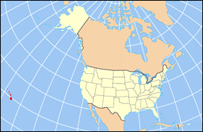
| Descripción | Map of USA with Hawaii highlighted and shown in true position |
| Fuente | http://www.nationalatlas.gov/printable/reference.html |
| Autor |
Licencia
This map was obtained from an edition of the National Atlas of the United States. Like almost all works of the U.S. federal government, works from the National Atlas are in the public domain in the United States.
Online access: NationalAtlas.gov | 1970 print edition: Library of Congress, Perry-Castañeda Library
|
Historial del archivo
Haz clic sobre una fecha y hora para ver el archivo tal como apareció en ese momento.
| Fecha y hora | Miniatura | Dimensiones | Usuario | Comentario | |
|---|---|---|---|---|---|
| actual | 16:30 2 abr 2007 | | 286 × 186 (21 kB) | MattWright | fix to more standard map colors |
| 19:09 1 abr 2007 |  | 286 × 186 (19 kB) | MattWright | {{Information |Description=Map of USA with Hawaii highlighted and shown in true position |Source=http://www.nationalatlas.gov/printable/reference.html |Date= |Author= |Permission= |other_versions= }} Category:Maps of the United States [[Category:Maps |
Usos del archivo
Las siguientes páginas usan este archivo:
Uso global del archivo
Las wikis siguientes utilizan este archivo:
- Uso en bcl.wikipedia.org
- Uso en bo.wikipedia.org
- Uso en da.wikipedia.org
- Uso en en.wikipedia.org
- Uso en fa.wikipedia.org
- Uso en hu.wikipedia.org
- Uso en id.wikipedia.org
- Uso en ja.wikipedia.org
- Uso en ko.wikipedia.org
- Uso en mrj.wikipedia.org
- Uso en mr.wikipedia.org
- Uso en pl.wikipedia.org
- Uso en pl.wikinews.org
- Uso en pl.wiktionary.org
- Uso en ro.wikipedia.org
- Uso en sv.wikipedia.org
- Uso en uk.wikipedia.org
- Uso en vi.wikipedia.org