
Archivo:1806 Mogg Pocket or Case Map of London, England - Geographicus - London-mogg-1806.jpg

Tamaño de esta previsualización: 800 × 436 píxeles. Otras resoluciones: 320 × 174 píxeles · 640 × 349 píxeles · 1024 × 558 píxeles · 1280 × 697 píxeles · 2560 × 1394 píxeles · 7000 × 3813 píxeles.
Ver la imagen en su resolución original (7000 × 3813 píxeles; tamaño de archivo: 7,83 MB; tipo MIME: image/jpeg)
| London in Miniature, with the Surrounding Villages Entire New Plan in which the Improvements both present and intended are actually reduced (by permission) from the surveys of the Several Proprietors. | ||||||
|---|---|---|---|---|---|---|
| Artista | ||||||
| Título |
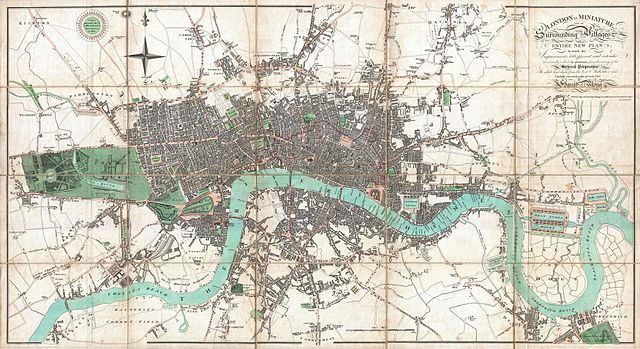
London in Miniature, with the Surrounding Villages Entire New Plan in which the Improvements both present and intended are actually reduced (by permission) from the surveys of the Several Proprietors. |
|||||
| Descripción |
English: An extraordinary first edition example of Edward Mogg's important 1806 case map of London, England. Covers the central part of London from Kensington to Greenwich and the East India Docks. Of this stunning map, Mogg writes ...like the clue of Ariadne, [it] will conduct him through the labyrinth, and, occasionally consulted, will enable him, unattended, to thread with ease the mazes of this vast metropolis Mogg's map of London offers extraordinary and beautifully engraved detail throughout noting all streets, parks, and numerous important buildings. Illustrates a relatively primitive state of development on the south shore of the Thames. The downtown area consumed by the London fire of 1666 is highlighted in red. Mogg's intention in this map is to highlight various city works and urban renewal projects which were being perused in the early 19th century. We have found a few references to various later editions of this map at auction and in libraries, but this is the only first edition we know of to have appeared on the market in the last 35 years. |
|||||
| Fecha | 1806 (dated) | |||||
| Dimensiones | altura: 19,5 in (49,5 cm); ancho: 36 in (91,4 cm) | |||||
| Número de inventario |
Geographicus link: London-mogg-1806 |
|||||
| Fuente/fotógrafo |
|
|||||
| Permiso (Reutilización de este archivo) |
|
|||||
Historial del archivo
Haz clic sobre una fecha y hora para ver el archivo tal como apareció en ese momento.
| Fecha y hora | Miniatura | Dimensiones | Usuario | Comentario | |
|---|---|---|---|---|---|
| actual | 23:29 23 mar 2011 | | 7000 × 3813 (7,83 MB) | BotMultichillT | {{subst:User:Multichill/Geographicus |link=http://www.geographicus.com/P/AntiqueMap/London-mogg-1806 |product_name=1806 Mogg Pocket or Case Map of London, England |map_title=London in Miniature, with the Surrounding Villages Entire New Plan in which the I |
Usos del archivo
La siguiente página usa este archivo:
Uso global del archivo
Las wikis siguientes utilizan este archivo:
- Uso en be.wikipedia.org
- Uso en bs.wikipedia.org
- Uso en ca.wikipedia.org
- Uso en hr.wikipedia.org
- Uso en hy.wikipedia.org
- Uso en hyw.wikipedia.org
- Uso en id.wikipedia.org
- Uso en it.wikipedia.org
- Uso en lmo.wikipedia.org
- Uso en pt.wikipedia.org
- Uso en ru.wikipedia.org
- Uso en zea.wikipedia.org